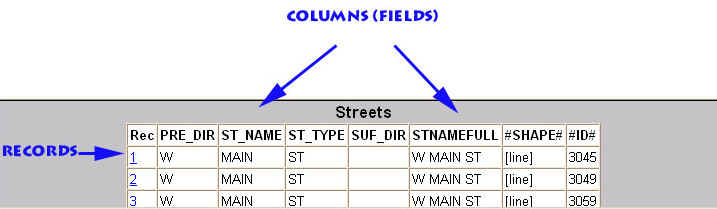
A data table consists of a series of columns (fields) and rows (records). The columns are category of a data such as a "street name" and the rows represent an individual feature such as a section of road. They take the form of either a number (such as the #ID# field) or a "string" which can contain both numbers and characters such as the alphabet (ST_NAME). When you use the query tool or the find tool you are essentially seeking information about records that share the same information in a particular column. For instance, you can query for all streets called "MAIN". The field ST_NAME contains street names and all the records or features that have that name are displayed. As such you would look at a record to identify characteristics of an individual feature. Clicking on the blue underlined record number will cause the map to zoom to that feature and highlight it in red.